 |
60.7 |
06-Aug-98 |
The view from Jefferson Rock, in Harpers Ferry. The Shenandoah River, on
the right, meets the Potomac River, on the left. |
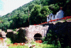 |
60.7 |
06-Aug-98 |
Lock 33, opposite Harpers Ferry. This area was severely damaged in the flood
of January 1996. |
 |
62.27 |
06-Aug-98 |
Feeder Dam No. 3. (?) |
 |
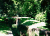
62.33 |
06-Aug-98 |
Lock No. 35, showing the drydock used in the 1800s for repairing canal boats.
A boat was let into the enclosure, then the water was let out, leaving the canal boat resting on the
concrete beams. |
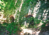 |
65.21 |
06-Aug-98 |
Limestone kilns, used until about 1960. |
 |
69.36 |
06-Aug-98 |
Antietam Aqueduct, No. 4. |
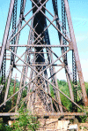 |
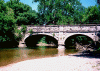
72.48 |
06-Aug-98 |
Trestle of Norfolk and Western Railroad, built c. 1908. |
 |
72.65 |
06-Aug-98 |
Shepherdstown River Lock. Lock gave boats from Shepherdstown access to
the canal; used until 1889. |
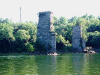 |
72.65 |
06-Aug-98 |
Two of five stone piers of old Shenandoah Valley Railroad bridge across the
Potomac, built in 1880. The piers rest on wood cribbing; now that Dam No. 3 is no longer
extant, the wood cribbing is rotting. On the West Virginia side is a monument to James
Rumsey, who demonstrated his steamboat here in December of 1787. |


