 |
47.65 |
05-Aug-98 |
Sun shining through the trees at Calico Rocks campground. |
 |
48.2 |
05-Aug-98 |
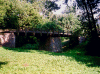
Remains of the old pivot bridge at Point of Rocks. The bridge could turn out of
the way on its central pier. Nothing remains of the pivot mechanism. Built in the 1830s, rebuilt in
1844 and 1852. |
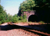 |
48.4 |
05-Aug-98 |
Point of Rocks Railroad Tunnel. Opened in 1868, rebuilt in 1909. Originally
built to hold two tracks. When the B&O deeded the canal property to the federal government in
1938, it retained enough canal land to add a second track outside the tunnel, which it finally did
in
the 1960s. The tracks in the tunnel were replaced by one track, which made room for larger
cars. |
 |
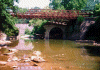
51.53 |
05-Aug-98 |
Railroad bridge across Catoctin Creek. |
 |
51.53 |
05-Aug-98 |
Remains of the Catoctin Creek Aqueduct, destroyed by flood in 1973. |
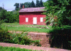 |
58.01 |
05-Aug-98 |
Lock 31 (Weverton), with lock house in the background. Lock was completed
in 1833. |
 |
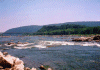
60 |
05-Aug-98 |
The Potomac near Harpers Ferry. |
 |
60 |
05-Aug-98 |
The Potomac near Harpers Ferry. The bridge for U.S. 340 is in the
background. |
 |
60.6 |
05-Aug-98 |
Harpers Ferry, WV, from the towpath. The two railroad bridges are to the
right, the piers to the left of the railroad bridges are the remains of a bridge washed out in 1936.
To the right is the Potomac, to the left is the Shenandoah. |
 |
60.7 |
05-Aug-98 |
Harpers Ferry railroad bridge. |


